
Films
Filmmaker | Storyteller | Cultural Documentarian
With a portfolio spanning award-winning documentaries, corporate films, and television series, Supriyo Nandy crafts compelling visual narratives that bridge anthropology culture, environment, and human stories. His works include Echoes (Films Division, Govt. of India), the Park Street campaign The Rising, and the acclaimed River of Life. Collaborating with global broadcasters and leading corporations like Aditya Birla Group and Tata Steel, he has brought to screen stories from the Sunderbans to the Himalayas, exploring themes from climate adaptation to music subcultures. Currently, he is creating the Climate Witness series with WWF and building a digital archive to preserve Himalayan heritage.
FILM PROJECTS
Produced Films
- Kinnara :- Anthropological film, on the Life cycle rites of the people of Kinnaur. The Film was presented in World Ethnological Congress Mexico. The Film was supported by the Ministry of External Affairs Government of India.
- “The Rising” :- Campaign film for the rejuvenation of Park Street, Kolkata.
- “River of Life” :- Explores Kolkata’s relationship with its rivers.
- “Sunderbans – The Beautiful Forest” :- Focuses on the livelihood impact in Sunderbans.
- “Park Street – The Living Ballad” :- A musical tribute to Park Street.
- “Songs of Freedom” :- Documentary on the metal band scene in Darjeeling Himalayas.
Feature-Length Documentary
- “Echoes” :- Produced for Films Division, Government of India, in 2016. This documentary explores contemporary Kinnaur through the lens of fraternal polyandry and women’s property rights, featuring interactions with six protagonists.

ECHOES – Synopsis
Echoes is a journey into the remote Himalayan district of Kinnaur, where society and nature are deeply intertwined, creating a unique social fabric shaped by centuries of adaptation to a harsh environment. Limited resources, extreme weather, and geographic isolation fostered traditions such as fraternal polyandry—brothers marrying a single woman—as a way to sustain families and communities.
Two decades after my maiden film Kinnara, I return to explore how winds of change—driven by the booming apple economy, education, tourism, and modern communication—are reshaping this once-isolated culture. These changes bring both progress and vulnerability, as traditional customs, crafts, music, and architecture face the risk of extinction under outside influences.
The film follows six Kinnauri families, each reflecting a different facet of this transformation
- Sangrathan Negi (Kalpa) :– An apple merchant and hotelier campaigning to protect Kinnaur’s cultural and natural heritage from hydroelectric projects and mass tourism.
- Chandrasukh Negi & Jagat Kumari (Sangla) :– A father-daughter weaving duo, custodians of sacred textile traditions, representing the many unmarried women of the region.
- Ratan Manjari :– Chairperson of the Mahila Kalyan Parishad, fighting for women’s property rights and challenging outdated customs that marginalize widows and unwed women.
- Lalita Pancharas :– Model, beauty entrepreneur, and political activist who bridges modern aspirations with respect for traditional customs, empowering local women with new livelihoods.
- Bagh Negi Family :– A polyandrous household that endured economic and geographic challenges through shared marriage, offering insights into the practicality of the tradition.
- Nav Negi (Reckong Peo) :– A travel entrepreneur preserving Kinnaur’s cultural heritage and advocating for awareness among youth to safeguard local art forms.
Through these intimate portraits, Echoes weaves two parallel narratives:
- A personal return to the filmmaker’s earlier journey, reconnecting with past subjects.
- A broader reflection on Kinnaur’s evolving identity—caught between tradition and modernity.
Ultimately, the film is a meditation on time, culture, and resilience—observing a society at a delicate crossroads, where the echoes of the past still shape the sounds of the present.
Corporate Films
- Produced for major corporations including Aditya Birla Group, Tata Steel, and others.
- I create CSR films that go beyond statistics to reveal the human faces behind corporate initiatives—stories of hope, resilience, and transformation. Drawing inspiration from pioneers like the Tata Group, whose legacy of community-first business has set the benchmark in India, my work captures authentic narratives that inspire trust, drive engagement, and showcase the true social impact of corporate responsibility.
Television Series
- “Spaceship Earth” :- Akshai TV, Japan.
- “Miracle in Calcutta” :- Japanese television program.
- “Ardhek Akash” :- Alpha TV Bangla, Women’s Day special.
- “Ki Likhi Tomayae” :- Talk show for Alpha TV Bangla.
Digital Campaigns
Studio-Quality Films. AI-Powered. Human-Driven
At Lights Camera Ai, we are redefining the future of visual storytelling. Born from decades of experience in documentaries, feature films, and corporate productions, our team isn’t just made up of filmmakers—we are communicators, driven by purpose, narrative, and innovation.
As demand metrics evolve and content consumption accelerates, so do we.
That’s why we’ve transitioned from traditional formats to launch a next-gen, AI-powered film production house focused on studio-quality advertising and communication films—created faster, smarter, and more affordably than ever.
Our Model: Premium Films, Membership Pricing
We offer a cost-effective membership model designed to support brands, agencies, and institutions that need regular, high-quality content without breaking the bank. Our unique blend of AI-enhanced workflows and human creativity ensures
- Faster Turnarounds
- Consistent Brand Messaging
- Cinema-Grade Output
- Affordable Pricing Plans
Whether it’s a product launch, a cause-based campaign, or a brand story, we turn your vision into visually striking, emotionally resonant content.
Led by Storytellers
At the helm of Tru Tone Picture, our creative studio, is Supriyo Nandy—a celebrated documentary filmmaker and digital media specialist who has worked across genres and platforms. Under his leadership, we remain rooted in authenticity while embracing the power of artificial intelligence to amplify stories like never before.
What We Do
🎥 Short Films & Commercials
🎬 AI-Powered Ad Films
📺 Branded Content
📹 Corporate & Training Videos
🎞️ Digital Campaign Films
Why Choose Us?
Studio-Quality Aesthetics
AI-Enhanced Efficiency
Real Filmmaking Expertise
Affordable Membership Options
Scalable for Startups to Enterprises
Let’s Tell Better Stories – Together
We’re not just adapting to the new media era. We’re building it—with creativity, empathy, and the transformative power of AI. Lights Camera Ai. Where Ideas Take Center Stage.
Media Projects
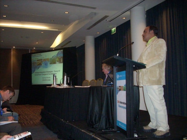
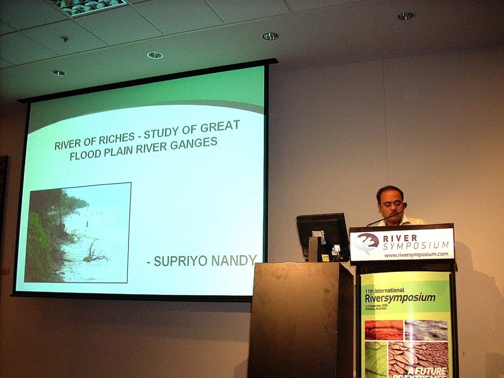
RIVER OF RICHES-STUDY OF GREAT FLOOD PLAIN RIVER : GANGES SUPRIYO NANDY
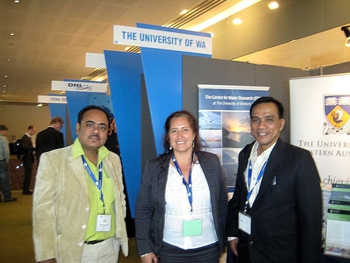
International Research Recognition
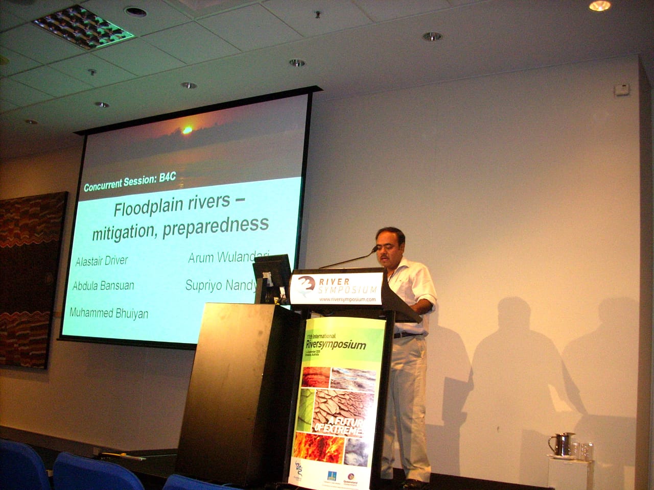
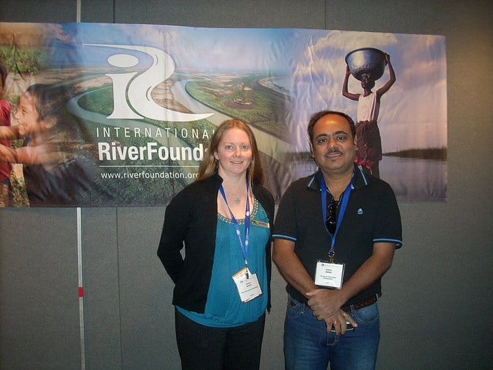
Supriyo Nandy has had the privilege of presenting two of his research papers at the prestigious River Symposium, a globally recognized forum on river science, management, and sustainability. His contributions were featured at the 2008 symposium in Brisbane and the 2010 symposium in Perth, where leading researchers, policymakers, and practitioners from around the world convened. These presentations underscore his commitment to advancing knowledge in the field and his dedication to addressing critical issues of water resources, environmental sustainability, and community resilience.

Introduction
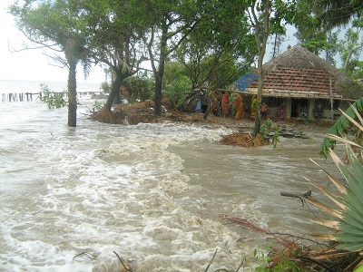
The response around the world to such catastrophes was predictable, more dams, higher leeves and sturdier embankments to contain rising waters. These days, however water – management experts are increasingly questioning whether traditional remedies make sense; in fact some contend that dams and other barierrs do more harm than good. But are human activities making India more flood-prone? Building cities on the world’s worst flood-prone area – the Indo-Gangetic plains – is not new. Over the past 40 years billions of dollars have been spent on river containment in India. Critics insist the impact has been limited and in some cases has had the perverse effect of aggravating damage caused by rain swollen rivers. Flood is the penalty human beings have to pay when they interfere with the rivers’ right of way. The paper tries to evaluate how India’s biggest challenge in sustainable development will lie in the ways it learn to use the Indo-Gangetic flood plains, which have the potential to feed not just India but large parts of Asia.
The ecologically appropriate water utilization model is yet to be developed, but the region’s rich traditions should provide some useful pointers. However, to use this rich annual Tift appropriately, what is also needed is political will and discipline. Dams and embankments have now become important causes of flood.
Introduction
With the meltdown of the Himalayan glaciers, embankments tend to break when river rises suddenly. According to Sir William Willcock’s account of 1920 the silt laden Himalayan flood waters not only enriched the soil and provided bumper crops but the fish brought down by it kept malaria down. The Government steadily destroyed the system by making permanent embankments. Traditional irrigators, regularly breached embankments to draw flood waters down canals to every field and pond. But the British made breaching illegal and reduced productivity in most districts of Bengal resulting the infamous famine. Will cocks’ analysis certainly needs to be sharply debated in these days of ‘sustainable development’, of this great flood plain river.
India’s first Prime Minister Jawaharlal Nehru, believed that dams will produce power, irrigation and control flooding and become the “temples” of a modern, secular state. Since then 400 large dams have been built in India, along with thousands smaller levees as well as 16,000 km of river embankments, but the area affected by floods has expanded from 2 million hectares to 9 million due to deforestation, poor urban drainage and other factors.
The River of Riches
Each year these rivers were flooded leaving behind a fresh layer of sediments. The Indo-Gangetic plains are a product of such floods. A recent study carried out by Rajiv Sinha, of Geosciences group, IIT Kanpur has brought to light amazing quantity of sediment load carried by the Ganga River in its present hydrodynamic regime. Gangetic Rivers erode bulk of the sediments from upstream areas in the Himalayas and deposit part of it in the alluvial plains and a significant part in the Bay of Bengal, says Sinha. His study reveals that the Ganga river annually erodes around 749 million tonnes of sediments, mostly from the Himalayas, brings about 729 million tonnes at Farrakka and finally dumps 95 million tonnes in the Bay of Bengal. Thus the floodplain of the Ganga gets an annual increment of about 65 million tonnes of sediments.
Year after year these rivers painstakingly deposit their load on the plains and have resulted in the green belt of the country, one of the most populated areas since times immemorial.
The river Ganga starts its 2427 km long journey from Gangotri glacier. Ganga basin has an area of about 1,093,400 sq km says Himanshu Thakur of South Asia Network on Dams, Rivers & People, New Delhi Incidentally Ganga River basin which is normally ravaged by floods form June to September each year is one of the most densely populated poorest areas in South Asia with largest collection of disaster affected people.
Changing courses by Ganga and its tributaries has been going on since times immemorial. In the recent years since 1925 Ganga has shifted from 4-9 km and the shifting channel is quite a problem for large tracts of land between West Bengal and Jharkhand.
The behavior of Ganges is well known, yet the problem occurs every year. This is because the spurt of population has driven people to occupy the flood pathways of the river. As long as the river is within its channel no one feels the pinch. The moment it tries to occupy the flood pathway, over which the river has all the right, people feel the pinch. It is for the government to check people from settling down in such areas.

Flood Control vs. Flood Management
In the middle of the 20th century, flood problems drew attention in South Asia. In India, the earlier approach had been to control flooding by structural measures, specifically by the construction of flood embankments and anti-erosion structures for the protection of riverbanks. Flood cushions were also provided in some reservoirs. However, it was soon realized that even though flooding could be reduced using these measures, it would never be possible to totally control floods. It was also recognized that it would not be possible to provide permanent protection to all flood prone areas for all magnitudes of floods. Providing protection would involve factors as diverse as the topographic limitations of the region as well as financial investment – and would entail prohibitively high cost of construction and maintenance.
Flood Management Strategy
Flood Management activities can be broadly classified in four major categories.
- Modifying the floods in order to keep the flood waters away from developed and populated areas by decreasing runoff, increasing channel capacity, or containing, diverting, or storing flood waters.
- Modifying susceptibility to flood damage by keeping people and developed areas out of flood hazard areas or by insuring that such developed areas are flood-proof.
- Modifying the loss burden by reducing the financial and social impact of flooding by providing post flood assistance and insurance.
- Bearing the losses.
All these measures for flood management can be classified as either structural or non-structural measures. Measures taken up under ‘modifying the flood’ are mostly physical measures and are termed ‘structural measures’, while those under the other three headings are mainly ‘non-structural measures’.
Structural Measures
Flood management in the form of physical measures to prevent the floodwaters from inflicting damage usually involves one of the following.
- Dams and reservoirs
- Embankment and flood walls
- River bank protection and anti-erosion structures.
- Natural detention basins
- Channel improvement
- Drainage improvement
- Diversion of flood waters
- Catchment area treatment/afforestation
Non-Structural Measures
Non-structural measures strive to keep people away from floodwaters. One must always bear in mind; however, the stark reality that flood plains belong to the river and that floods, commonly perceived only as a curse, can be turned into a blessing in disguise if property prepared for. Flood plains can be used judiciously and shared with developed areas by vacating and permitting use of the land by the river where never the situation calls for it. This approach allows the flood plains to be utilized and reduces the disaster dimension, while retaining its beneficial effects.
Non-structural measures are very cost effective and can be readily implemented. In recognition of the fact that it may not be possible to halt human encroachment in flood plains areas, the main thrust is now on non-structural flood management measures. Non-structural measures can be grouped broadly as follows.
- Flood forecasting and advance warning.
- Flood plain zoning
- Flood proofing
- Disaster preparedness and response planning
- Disaster relief
- Flood fighting
- Flood insurance.
Flood Forecasting and Advance Warning
Flood forecasting and advance warning is gaining the greatest attention of planners as the approach of choice when considering non-structural measures to modify the susceptibility to flood damage, and is gaining acceptance with the public as well. Flood forecasting forewarns the resident population when the river is going to use its flood plain, to what extent, and for how long. In 1959, the Government of India laid the foundation for a strategy of laying more emphasis on non-structural measures by establishing a nationwide flood forecasting and warning system under the Central Water Commission (CWC). The state governments of the individual states often supplement these with their own efforts by providing reliable advance information/warning about impending floods. Advance warning helps in preventing the loss of human lives and moveable property and in reducing human misery to a considerable extent. With advance warning, people, cattle, and valuable moveable property can be removed to safe places upland of the areas that will be inundated.
Dissemination of Flood Warnings
Advance flood warning, by disseminating flood-forecast information, is the most common non-structural measure of flood management. The important considerations for advance flood warning include.
- Accuracy of the flood forecast;
- Timeliness of the advance warning; and
- Proper dissemination of the advance flood warning.
The importance of the first two is well known and is undertaken during the formulation of the flood forecast. Equally important, however, is dissemination to the right user since it is the public that is the end user of these warnings. Flood warnings are disseminated by telephone, wireless network, police wireless, flood telegrams, fax, and special messenger. Advance flood warnings are generally disseminated to the following.
Flood control rooms – State governments usually have control rooms in the capital as well as the administrative headquarters. Advance flood warnings are passed on to these control rooms and it is their responsibility to inform all concerned to take necessary action.
Civil Authorities – These authorities are generally in charge of announcing warnings through loudspeakers in the areas that are likely to be affected. They are also generally in charge of disaster preparedness for the area and for transporting people to safer places. In the event of flooding, these authorities are also responsible for providing relief measures such as boats, drinking water, food packets, fodder for cattle, and medicines.
Engineering Authorities – Advance flood warnings are provided to engineers in charge of structure such as dams, reservoirs, flood embankments, anti-erosion works, railways, roads, and bridges in areas likely to be affected in order to enable them to take precautionary measures for the safety of the structures.
Strategic Establishment – Oil refineries, power stations, coalmines, factories, and other industrial units located in the areas likely to be affected are also issued flood warnings.
Mass Communication – Flood warnings are also sent to the press, and to radio and television stations, so that they can publish/announce appropriate warnings to the public. In India, during the flood season, the station of All India Radio and local television channels reserve a particular time slot every evening and/or morning for flood news including advance flood warnings. The general public is aware of this and they know that they can get reliable information in time.
Flood Signals – In areas prone to frequent flooding, a system of light signals can be used to indicate impending danger. For example, a yellow signal can indicate a minor warning such as may be needed when a flood occurs within the river, whereas a red signal can indicate a more serious threat such as when a large area is likely to be inundated. Such a system is in practice in the Damodar basin in India.
Village Administration – In the case of particular villages, advance flood warnings are sent not only to the central flood control rooms and civil authorities, but also directly to the gram panchayat (village administration), schools, hospitals, and dispensaries among others.
In 1991, the Central Water Commission evaluated the performance of the flood protection work. The study showed that the anti-erosion work had helped to divert the main current towards the north, thereby reducing erosion in the town and downstream areas. Similarly, the system of dykes was functioning well and was adequately checking the spillage of flood water into Dibrugarh and its suburbs providing a sense of security to the local population. However the floods of 1988 alerted the population to the necessity of regular monitoring and further raising and strengthening of these embankments. There is an urgent need to carry out flood plain zoning in the protected areas and to regulate development activities in the town and its adjoining areas. The gradual shifting of development activities from the present vulnerable areas of the town to comparatively safer higher areas will also help to reduce flood damage potential.
Performance of Flood Forecasting in India
|
Year
|
No of forecasts issued
|
No. of forecasts within ±15 cm or ±20%
|
% of accurate forecasts
|
|---|---|---|---|
Conclusion
The basic problem seems to be the mind set of decision-makers who believe that floods are a nuisance and must be controlled. Little has been done to live with floods or use the water advantageously. The Gangetic flood plains are getting increasingly waterlogged because of indiscipline in land use systems. The embankments can protect people from floods permanently has been proved false.
A river basin is the most appropriate hydrological unit for the planning and management of water resources. Integrated river basin development aims at the optimum use of basin water resources to best meet all of the water needs of a basin. It is a tool that can be used to address issues related to both the positive and the negative aspects of floods and droughts in a basin. Effective flood management needs to consider the whole basin and requires that methods that can reduce flood losses should be considered and used where appropriate. There should be a master plan for flood management for the basin. Sound watershed management through extensive soil conservation, catchments area treatment, and construction of check dams should be promoted to reduce the intensity of flood. Adequate flood cushions should be povided in water storage projects wherever feasible to facilitate better flood management.
A judicious mix of structural and non-structural measures would optimize the benefits that accrue from structural measures alone. An extensive network of flood forecasting stations should be established to issue timely warnings to settlements in flood plains. Flood plain zoning and strict regulations on the location of settlement and economic activities in flood zones will help minimise loss of life and property. While physical flood protection work like embankments and dykes will continue to be necessary, the emphasis should be on non-structural measures such as flood plain zoning, to minimise losses and reduce the recurring expenditure on flood relief.

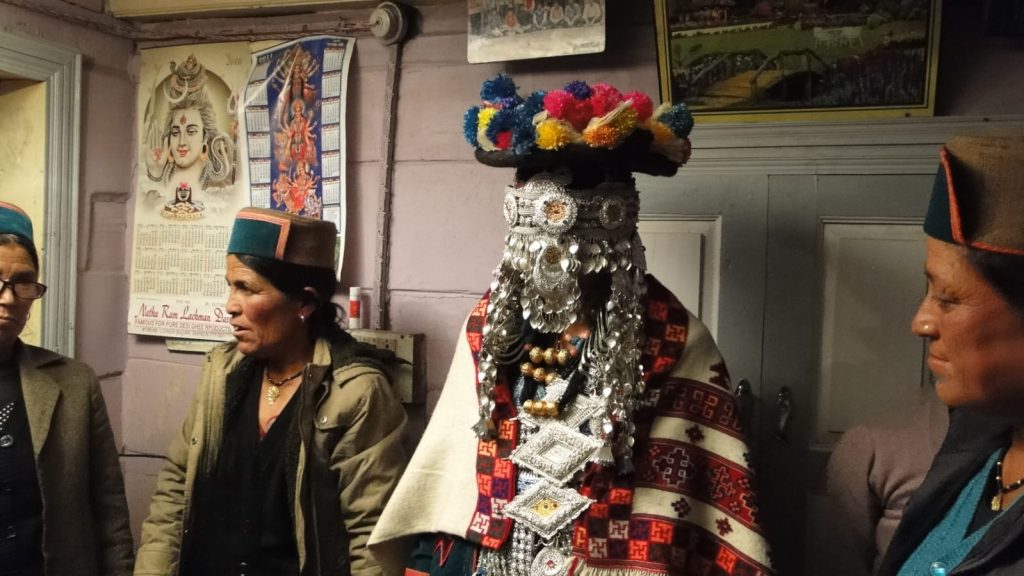
Digital Archive for Preserving Kinnaur & Laul-Spiti Himalayan Cultural Heritage
Objective
The project aims to create a comprehensive digital archive documenting the rich cultural heritage of the Kinnaur and Laul-Spiti regions. This archive will encompass a wide range of cultural elements, including scriptures, languages, rituals, folklore, livelihood practices, stories, mythologies, food practices, architecture, traditional designs, and other aspects currently threatened by modernization and changing times.

Scope
The initiative focuses on preserving the unique culture of the tribes and indigenous communities in Kinnaur and Laul-Spiti. It will involve.
- Documentation of Scriptures and Languages :- Recording and translating ancient texts, and documenting local languages and dialects.
- Rituals and Folklore :- Capturing traditional ceremonies, oral histories, and folklore passed down through generations.
- Livelihood Practices :- Recording traditional agricultural, artisanal, and other livelihood practices.
- Stories and Mythologies :- Collecting and preserving local stories, legends, and mythological narratives.
- Food Practices :- Documenting traditional recipes, food preparation methods, and culinary practices.
- Architecture and Traditional Designs :- Photographing and cataloging traditional architectural styles and designs unique to the region.
Long-term Vision
The long-term objective is to establish a people’s museum dedicated to Kinnaur and Laul-Spiti. This museum will serve as a physical extension of the digital archive, providing a space for community engagement, education, and preservation of indigenous knowledge.
Importance
This digital archive will play a crucial role in ensuring the continuity of the region’s unique cultural practices and traditions. It will.
- Preserve Indigenous Knowledge :-Safeguard valuable economic, political, social, tribal, and cultural knowledge for future generations.
- Support Research :-Provide a rich resource for researchers studying the region’s heritage and cultural practices.
- Promote Cultural Continuity :- Help maintain the cultural identity of the Kinnaur and Laul-Spiti communities amid rapid modernization.

Conclusion
The digital archive project represents a critical intervention in the conservation and continuity of Kinnaur and Laul-Spiti’s indigenous cultures and traditions. By documenting and preserving these cultural elements, the project ensures that the rich legacy of these regions will endure and continue to be celebrated for generations to come.

Conservation Methodologies for the Kinnaur & Laul-Spiti Digital Archive Project
1. Digital Documentation:
- High-Resolution Scanning and Photography :- Use high-resolution scanners and cameras to digitize manuscripts, artworks, artifacts, and architectural designs.
- Audio and Video Recording :- Capture oral histories, folklore, rituals, and traditional music using high-quality audio and video equipment.
2. Cataloguing and Metadata:
- Structured Database Management :- Develop a robust database to store digitized materials, ensuring each item is cataloged with detailed metadata (e.g., origin, date, cultural significance).
- Standardized Taxonomy :- Implement standardized classification systems and keywords to make searching and indexing efficient
3. Community Involvement:
- Oral History Projects :- Engage local elders and community members in recording their stories, traditions, and knowledge.
- Participatory Workshops :- Conduct workshops to train community members in documentation techniques, ensuring ongoing local involvement and expertise.
4. Preservation Techniques:
- Conservation of Physical Materials :- Implement best practices for the physical conservation of documents and artifacts, including climate-controlled storage and protective housing.
- Digital Preservation Standards :- Follow international digital preservation standards to ensure the longevity and accessibility of digital files, including regular backups and use of archival file formats.
5. Translation and Transcription:
- Multilingual Documentation :- Translate and transcribe texts and recordings into multiple languages to broaden accessibility and understanding.
- Annotation and Commentary :- Add scholarly annotations and commentary to provide context and enhance the educational value of the materials.
6. Educational and Outreach Programs:
- Cultural Education :- Develop educational programs and materials for schools and universities to teach about the cultural heritage of Kinnaur and Laul-Spiti.
- Public Exhibitions and Events :- Organize exhibitions, cultural events, and talks to engage the broader public and raise awareness of the region’s heritage.
7. Collaborations and Partnerships:
- Academic and Cultural Institutions :- Partner with universities, museums, and cultural organizations to share resources, expertise, and support.
- Grant Funding and Sponsorships :- Seek funding from governmental, non-governmental, and international bodies dedicated to cultural preservation.
8. Digital Access and Dissemination:
- Online Platforms :- Develop a user-friendly website and mobile app to provide global access to the digital archive.
- Social media and Digital Marketing :- Use social media and digital marketing strategies to promote the archive and engage a wider audience.
9. Research and Documentation:
- Field Research :- Conduct ethnographic and archaeological field research to discover and document new cultural artifacts and practices.
- Scholarly Publications :- Publish research findings in academic journals and books to contribute to the broader body of knowledge on Himalayan cultures.
10. Sustainable Practices:
- Environmental Conservation :- Ensure that conservation practices do not harm the natural environment, promoting sustainability alongside cultural preservation.
- Renewable Energy :- Utilize renewable energy sources for digital archive infrastructure to minimize ecological impact.
By implementing these methodologies, the project will effectively preserve and promote the rich cultural heritage of the Kinnaur and Laul-Spiti regions, ensuring its endurance for future generations.